
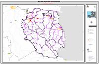
Interconnected Regional Electricity Networks: Nord-Est
- Shows the interconnected regional network planned for Nord-Est as of April 2018.
- Legend separates EDH's existing network from the network built under USAID's PPSELD pilot, so existing and added infrastructure can be told apart.
- Thermal generating plants are located on the sheet, with the national road network as a base layer.
- Drawn at 1:120,000 in large format, which is a planning scale rather than an operational one.
- Planning intent, not an asset record: the regional concession tenders that followed did not all reach award.
This is one sheet of a nine-sheet map series ANARSE published in May 2018, dated April 2018, showing the interconnected regional electricity networks planned across Haiti. This sheet covers Nord-Est.
The sheets are large-format planning drawings at 1:120,000, printed at roughly 34 by 22 inches. The legend is what makes them useful: it distinguishes the network already operated by Électricité d'Haïti from the network built under the USAID Pilot Project for Sustainable Electricity Distribution (PPSELD), locates thermal generating plants, and carries the national road network as a base layer. Read together with the commune-level allocation ANARSE published in January 2019, the series is the clearest surviving statement of how the regulator intended to partition the country between interconnected regional grids and off-grid mini-grid concessions.
Treat the sheets as planning intent rather than as a record of assets built. They date from the period when ANARSE was preparing the regional concession tenders, and the pre-qualification rounds that followed did not all reach award.
Full Document Text
Extracted text from the original document for search indexing.
How to cite
Autorité Nationale de Régulation du Secteur de l'Énergie (ANARSE), 2018, Interconnected Regional Electricity Networks: Nord-Est, https://anarse.gouv.ht/wp-content/uploads/2018/05/Reseaux_Nord-est.pdf