
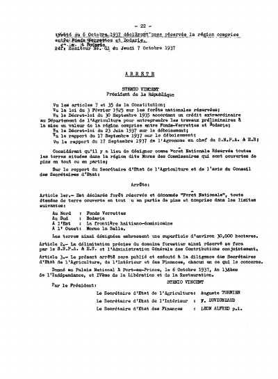
Arrêté of 6 October 1937 declaring a National Forest between Fonds-Verrettes and Bodarie
- About 30,000 hectares are reserved, bounded by Fonds-Verrettes, Bodarie, the Dominican border and Morne la Selle.
- Only pine-covered land, wholly or partly, falls inside the designation.
- Delimitation is joint between the agricultural service and the Administration Générale des Contributions.
- This is the origin of the Forêt des Pins, whose modern park instruments the corpus also holds.
The arrêté of 6 October 1937, published in Le Moniteur No. 81 of 7 October 1937 under Sténio Vincent.
Article 1 declares a reserved forest, named Forêt Nationale, every stretch of land wholly or partly covered in pine within limits given as Fonds-Verrettes to the north, Bodarie to the south, the Haitian-Dominican border to the east and Morne la Selle to the west, an area of about 30,000 hectares. Article 2 puts the precise delimitation with the agricultural service and the Administration Générale des Contributions acting jointly. The preamble cites the law of 3 February 1926 on reserved national forests, the decree-law of 30 September 1935 granting an extraordinary credit for preliminary works in the same region, and the 1937 decree-law on deforestation.
This massif is the largest remaining pine stand in Haiti and the catchment above the Cul-de-Sac plain. The corpus holds the 2017 arrêté amending the 8 January 2014 instrument that divided the Parc National Naturel Forêt des Pins in two, so the 1937 designation and its modern successors can be read together.
Full Document Text
Extracted text from the original document for search indexing.
How to cite
Présidence de la République d'Haïti, Arrêté of 6 October 1937 declaring a National Forest between Fonds-Verrettes and Bodarie, https://www.fao.org/faolex/country-profiles/general-profile/en/?iso3=HTI
- Rights holder
- Government of Haiti