
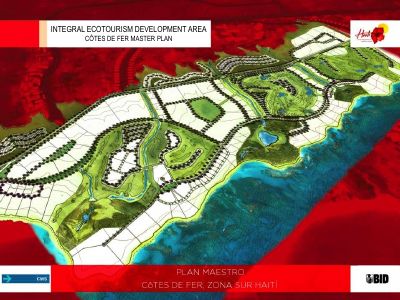
Côtes de Fer Master Plan: Integral Ecotourism Development Area
- The plan sets out a five-phase build-out for an integral ecotourism development area at Côtes de Fer.
- Haiti's air access runs through Port-au-Prince international airport plus national airports at Les Cayes and Jacmel, the latter under renovation when the plan was written.
- The road-distance table gives 190 km from Côtes de Fer to Port-au-Prince, 105 km to Les Cayes, 83 km to Miragoâne and 109 km to Petit-Goâve.
- The plan covers environmental feasibility and sustainability alongside the market and the phasing.
- It is published in English and Spanish. There is no French edition.
A master plan for an integral ecotourism development area at Côtes de Fer on Haiti's southern coast, issued in English and Spanish, covering transportation, location, target market, a five-phase build-out, environmental feasibility and sustainability.
The accessibility chapter is the substantive part for planning purposes. It records that Haiti's air transport runs through Port-au-Prince international airport plus two national airports at Les Cayes and Jacmel, the latter under renovation at the time of writing, and it carries a road-distance table from Côtes de Fer to the major cities: 190 km to Port-au-Prince, 105 km to Les Cayes, 83 km to Miragoâne, 109 km to Petit-Goâve, and onward figures for Bainet, Aquin, Jacmel and Jérémie.
It is one of the few site-level tourism development plans the Haitian state has published.
How to cite
Ministry of Tourism, 2013, Côtes de Fer Master Plan: Integral Ecotourism Development Area, https://tourisme.gouv.ht/
- Rights holder
- Government of Haiti