
Seismic Microzonation of Port-au-Prince
- The definition given at the launch is the operative one for reading everything the project later produced: a seismic microzonation maps the zones whose seismic response is homogeneous, taking in regional seismic hazard, geological and topographic site effects (the modification of the bedrock signal by local lithology and topography), and induced effects such as landslides and soil liquefaction. It may also include potential surface deformation associated with seismogenic faults.
- The purpose is stated as decision support rather than science: a tool for taking seismic risk into account in territorial planning and construction, in support of or as a complement to regulation. Building vulnerability and damage simulation are named alongside it.
- The timetable was 18 months for Port-au-Prince, set in September 2011. The synthesis report was dated December 2013, so the work ran about twice the planned duration.
- The city was divided into five study zones: Zone 1 the city centre, Zone 2 Fort National, Zone 3 Bourdon and Canapé Vert, Zone 4 Pétion-Ville, Zone 5 Saint-Gérard, Deprez and Carrefour-Feuilles.
- The consortium is three institutions with two categories of participant: LNBTP, BME and BRGM collaborating, with CNIGS and the universities participating. That division of labour is worth noting because the later reports are signed differently.
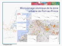
This 14 September 2011 presentation outlines the planned seismic microzonation work for the urban zone of Port-au-Prince. It identifies the collaboration among LNBTP, BME and BRGM, with participation from CNIGS and universities, and states that the Port-au-Prince microzonation was planned for eighteen months. The presentation delineates the study area through several urban zones, including Centre ville, Fort National, Bourdon-Canape Vert, Petion-Ville and Saint Gerard-Deprez-Carrefour-Feuille. It defines seismic microzonation as mapping areas with homogeneous seismic response, taking account of regional seismic hazard, geological and topographic site effects, induced effects such as landslides and soil liquefaction, and potentially surface deformation linked to seismogenic faults.
The objective is to support consideration of seismic risk in land-use planning, construction and anti-seismic regulation. The slides say the regional hazard work would refer to the seismic hazard map produced in 2010 by USGS and would evaluate the elastic response spectrum at rock. The presentation distinguishes macrozonation, based mainly on lithological site effects and NEHRP soil classes, from microzonation, which combines lithological and topographic effects, liquefaction and landslide hazards and uses more precise soil-specific response spectra.
It lists project staffing for BRGM and Haitian partners, steps from data collection through mapping, equipment needs, and deliverables including training, databases, maps at 1:10,000 in high-stakes sectors and 1:25,000 elsewhere, explanatory reports, project data to feed GIS systems for BME, LNBTP and CNIGS, and a workshop for final users.
Full Document Text
Extracted text from the original document for search indexing.
How to cite
Laboratoire National du Batiment et des Travaux Publics (LNBTP), 2015, Seismic Microzonation of Port-au-Prince, https://lnbtp.gouv.ht/microzonage/MZ_PAP.pdf