
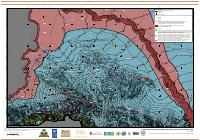
Port-au-Prince Seismic Classification Map
Summary: The seismic soil classification map for Port-au-Prince, revision 1 of 15 December 2010, produced by the GEER Team with William Lettis & Associates. It assigns NEHRP site classes B, C, D and F across the urban area and plots the surface-wave test sites with their measured velocities, giving designers the site-class input the building code requires without a site investigation of their own.
Key Findings
- The map exists to supply one code input: the NEHRP site class, on which the design spectrum depends. Classes B, C, D and F appear across the mapped area, so the same city spans stiff rock-like ground and soils requiring site-specific evaluation.
- The presence of class F is the finding a designer should not miss, because F soils are precisely those the code will not let you assign a standard spectrum to; they require site-specific response analysis.
- Measured shear-wave velocities are printed at each test site rather than left in an appendix, ranging among the sites legible on the sheet from 232 m/s at TL33 to 949 m/s at TL12. That spread across a single agglomeration is the physical reason a citywide default site class would be wrong.
- The classification is tied to the same geological mapping as its companion sheet, including the artificial fill west of the 1785 coastline and the supposed faults intersecting Mio-Pliocene alluvial deposits, so the site classes can be read against the deposits that produce them.
- It is a rapid post-earthquake reconnaissance product at revision 1, dated 15 December 2010, and it predates the 2013 BRGM-LNBTP-BME microzonation, which covers the same ground with a fuller method. Use this sheet for its measured velocities and the microzonation for design parameters.
How to cite
National Laboratory for Buildings and Public Works (LNBTP), 2010, Port-au-Prince Seismic Classification Map, https://lnbtp.gouv.ht/macrozonage/PAP_PDFs/pap_classification_sismique_2010_fr.pdf