
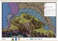
Port-au-Prince Geological Map
Summary: The geological map of Port-au-Prince at 1/10,000-scale detail, revision 1 of 15 December 2010, produced by the GEER Team with William Lettis & Associates after the 12 January 2010 earthquake. It maps nine surficial units from historic artificial fill through Holocene fluvial, delta, estuarine and terrace deposits to Pliocene alluvial fans and the Miocene limestone substratum, plots supposed principal and secondary faults intersecting Mio-Pliocene alluvial deposits, and locates the surface-wave test sites colored by NEHRP site class.
Key Findings
- The map's most consequential single unit is artificial fill: Af marks the ground reclaimed from the sea west of the 1785 coastline, which the sheet reconstructs from the JCB Archive of Early American Images. Built land on former seabed in a port city is where liquefaction and amplification are expected, and the map lets a user identify it street by street.
- The surficial stratigraphy is ordered by depositional setting rather than by age alone: fluvial alluvium in the active channels of major watercourses (Qhac), alluvial delta deposits along the western edge of the mapped area (Qhad), marine or estuarine deposits intermixed with alluvial fan and local fill (Qham), lower alluvial terrace within flood zones (Qht1), upper alluvial terrace bordering major watercourses and inter-massif valley margins (Qht2), plain or alluvial fan deposits (Qphf), steep alluvial fans along the mountain front (Pf), and the Miocene limestone substratum outcropping along that front.
- Fault confidence is encoded in the line style rather than hidden: long dashes indicate relatively high confidence in the trace, short dashes a less certain trace, and the faults shown are described as supposed principal and secondary faults intersecting the Mio-Pliocene alluvial deposits. A reader can therefore separate mapped certainty from inference.
- The geophysical control is on the face of the map. Surface-wave test sites are plotted and colored by NEHRP site class, each labeled with its measured velocity, which ranges among the sites legible on the sheet from 232 m/s at TL33 to 949 m/s at TL12, a factor of four across the same urban area.
- This is revision 1 of a rapid post-earthquake product, dated 15 December 2010, eleven months after the event, and it is one of three companion sheets, the others being the seismic soil classification map and the combined geological and damage map.
How to cite
National Laboratory for Buildings and Public Works (LNBTP), 2010, Port-au-Prince Geological Map, https://lnbtp.gouv.ht/macrozonage/PAP_PDFs/pap_carte_geologique_2010_fr.pdf