
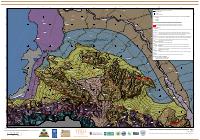
Geological and Damage Map for Port-au-Prince
Summary: The combined geological and damage map for Port-au-Prince, revision 1 of 15 December 2010, produced by the GEER Team with William Lettis & Associates. It overlays observed earthquake damage on the same surficial geology, fault traces and NEHRP-classed test sites as its companion sheets, so that damage can be read against the deposit it sits on rather than against the street plan alone.
Key Findings
- The sheet's purpose is the overlay, not either layer alone: earthquake damage is plotted on the same geological units, fault traces and NEHRP-classed test sites as the geological and soil-classification sheets, which is what allows damage concentration to be attributed to ground conditions.
- Its real title is broader than a damage map. The sheet is titled the geological and damage map for Port-au-Prince, and it carries the full geological legend, so a user who wants only the damage layer is holding a geological map as well.
- The geological units carried over are the ones that matter for shaking: artificial fill on land reclaimed west of the 1785 coastline, fluvial alluvium in active channels, delta and estuarine deposits, lower and upper alluvial terraces, plain and fan deposits, steep fans along the mountain front, and the Miocene limestone substratum at the front.
- Fault traces are shown with their confidence encoded in the dash length, long for a relatively well-established trace and short for a less certain one, and are described as supposed principal and secondary faults intersecting the Mio-Pliocene alluvial deposits.
- This is revision 1 dated 15 December 2010, a rapid reconnaissance product eleven months after the earthquake, and the third of three companion sheets.
How to cite
National Laboratory for Buildings and Public Works (LNBTP), 2010, Geological and Damage Map for Port-au-Prince, https://lnbtp.gouv.ht/macrozonage/PAP_PDFs/pap_degats_2010_fr.pdf