
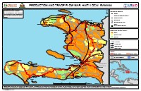
Production and Trade Flow Map: Haiti Local Banana
- Shows banana production status at the commune level.
- Identifies key market centers for bananas.
- Illustrates trade flows of bananas, including surplus and deficit areas.
- Highlights cross-border markets for bananas.
- Details the geography of marketing systems relevant to food security.
This production and trade flow map, published by FEWS NET in April 2018, illustrates the geography of marketing systems relevant to food security outcomes in Haiti, specifically focusing on local bananas. The map details production status at the commune level, indicating areas of surplus, deficit, and self-sufficiency. It also identifies key market centers and trade flows, including cross-border markets, and distinguishes between large, medium, and small trade flows. The map was created in collaboration with local government ministries, market information systems, NGOs, and private sector partners, using both qualitative and quantitative data.
Full Document Text
Extracted text from the original document for search indexing.
How to cite
FEWS NET, 2018, Production and Trade Flow Map: Haiti Local Banana, accessed via HaitiDocs, https://www.haitidocs.org/doc/fews-net-2018-production-trade-flow-map