
Land Tenure and Property Rights in Haiti
Summary — This USAID issue brief explains why land tenure and property rights became urgent for Haiti's post-earthquake recovery in January 2010.
Key Findings
- Adds Haiti-specific evidence from Land Portal's broader Haiti keyword search.
- Supports research on land administration, land tenure, cadastre, housing reconstruction, territorial information, rural land management or property-rights programming.
- Metadata was authored manually from local PDFs and recovered source records.
Full Description
The brief links emergency relocation, rubble clearance, return to damaged parcels, missing land documents, informal occupation, municipal property taxation and risk-prone areas to the land-tenure agenda after the January 12, 2010 earthquake. It is shorter than the later USAID country profile but provides immediate post-disaster framing.
Full Document Text
Extracted text from the original document for search indexing.
USAID ISSUE BRIEF
LAND TENURE AND PROPERTY
RIGHTS IN HAITI
THE IMPORTANCE OF LAND TENURE AND PROPERTY RIGHTS ISSUES
AND POST-EARTHQUAKE RECOVERY IN HAITI
PROPERTY RIGHTS AND RESOURCE GOVERNANCE BRIEFING PAPER 6
SUMMARY
The January 12, 2010, earthquake in Haiti killed an estimated 200,000 people in Port-au-Prince metropolitan
area and neighboring zones. As a result of extensive devastation, hundreds of thousands are homeless. The
government has announced plans to relocate 400,000 people to camps outside the city.1 Recent accounts of
people fighting over scarce tents2 and other forms of shelter foreshadows possible conflicts over land that may
arise as the focus shifts from immediate emergencies to long-term relief and recovery. Thousands of residents of
Port-au-Prince heading for other cities, seeking undeveloped land in rural areas, or returning to land held by
relatives, will increase pressure upon and the potential for conflict over land. An Office of Coordination for
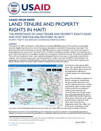
Humanitarian Assistance (OCHA) situation map for population movement out of Port-au-Prince (January 24,
2010) indicates areas into which large numbers of people are moving (see below).
Land tenure and property rights
issues will increasingly come to the
fore as the Haitian government and
aid organizations attempt to
relocate people onto undeveloped
land.
Beyond the immediate acquisition of
land for emergency resettlement,
the government and donors will
need to address land tenure conflict
and property rights as large swaths
of Port-au-Prince are cleared of
rubble and the planning and
reconstruction process gets under
way and people attempt to return
and reclaim their parcels. New and
old property claims are up for grabs,
land documents related to both
urban and rural areas have
disappeared under the rubble, and
the process of asserting control
over land in both earthquake-affected areas and areas into which IDPs are relocating is already underway.
Eyewitness accounts in the week following the earthquake note that occupation of vacated/damaged sites is
already occurring. Local levels of government in earthquake affected areas are overwhelmed and poorly funded
1
http://www.telegraph.co.uk/news/worldnews/centralamericaandthecaribbean/haiti/7048954/Haiti-earthquake-400000-to-be-resettled-outside-Port-au-Prince.html
2
http://www.latimes.com/sns-ap-cb-haiti-earthquake,0,6476623.story?page=2
January 2010
1
but have an inherent vested interest in secure tenure arrangements due to grassroots pressures on local elected
officials, and due especially to the municipal (commune) levy of taxes on “built properties” through the
Contribution Foncière des Propriétés Baties (CFPB). Rural jurisdictions—Conseils d’Administration des Sections
Communales (CASEC)—also have a strong vested interest in property, particularly urbanized communal sections
on the fringes of Port-au-Prince’s metropolitan communes. Like municipalities, communal sections have the right
to census “built” properties for the levy of CFPB property taxes.
The earthquake has given rise to hundreds of thousands of homeless people from poor neighborhoods, including
those located in flood plains, and the departure of thousands of urban residents for other areas of Haiti. The
sudden arrival of large numbers of Port-au-Prince residents in provincial towns and rural areas may stress local
economies and property arrangements. Latent land tenure conflicts hidden from view due to previous outmigration of rural people to the cities and overseas may resurface as urban-dwellers return to the countryside.
The damage to buildings in urban areas by the earthquake has created an unprecedented opportunity to relocate
urban populations away from risk-prone areas like fault lines and flood plains in the metropolitan area. This
process is already underway as the government and disaster response agencies clear land in the area of Croix
des Bouquets for tent cities. These tent cities are likely to evolve into long-term housing arrangements for poor
families. These trends create opportunity for the assertion of zoned control over lowland flood plains along the
coastal littoral and the Cul de Sac plains.
A special focus of interest should be the fragile slopes of Morne l’Hôpital and peri-urban areas along the eastwest ridge from Pétionville through Port-au-Prince and Carrefour. The steeply sloped Morne l’Hôpital benefits,
at least theoretically, from its special legal status as a “public utility,” a protected area off limits to construction
due to the high risk of erosion and its importance as a source of spring-fed water for CAMEP (Centrale Autonome
Métropolitaine d’Eau Potable), the public water utility of Port-au-Prince. Legally, all construction on the slopes of
Morne l’Hôpital is illegal in the absence of a formal waiver of building restrictions. This special zone is also
formally protected by a special planning and enforcement mechanism, OSAMH, an agency linked to the Ministry
of Interior. OSAMH has been active pre-earthquake and worked closely with USAID-funded initiatives to
protect the slopes of Morne l’Hôpital, and is an essential stakeholder and partner for initial rapid assessment of
property and current post-earthquake efforts to build houses on the slopes of Morne l’Hôpital. The postearthquake period provides an unprecedented opportunity to assert control over Morne l’Hôpital as a legally
protected zone and prevent new housing construction on fragile slopes essential to flood control and the
metropolitan water supply.3
Haiti does not have an effective national cadastre and lacks a comprehensive, functional system for recording
land ownership. Prior to the earthquake, customary arrangements and knowledge characterized the tenure of
Haiti with only 40% of landowners possessing documentation such as a legal title or transaction receipt.
Registration was more common in Port-au-Prince and other rural areas. Some areas of highly productive land,
such as the irrigated zones of the Artibonite Valley and Gonaives Plains, created local cadastres, but they have
not been maintained and records are not current.4 In Haiti, the Direction Generale des Impôts (DGI) has been
responsible for maintaining and updating registration records. However, the veracity and accuracy of land
records is suspect, and there is widespread distrust of government institutions, including those responsible for
documenting, maintaining, and upholding land claims. The current status of documents related to land ownership
is unknown. However, the DGI building has been severely damaged, and the current status of land records or
efforts to secure them is unknown. Many advocate as a priority the recovery and protection of land records
held at the DGI.
POST-EARTHQUAKE RECOVERY, LAND TENURE, AND PROPERTY RIGHTS
A number of issues related to land and other property are already evident, particularly in Port-au-Prince.
Massive numbers of people have moved or are being resettled to undeveloped land. The status of prior claims
on these lands is not always clear. Temporary homes are springing up amidst the debris of destroyed buildings; it
is unclear whether these new structures belong to the original claimants of the land or have been built by new
occupants. The massive demolition and removal of debris and recoverable materials also raises the question of
3 Morne L’Hôpital was declared an utilité publique by an arrêté (decree) dated November 17, 1978; a zone protégée in a law dated August 27, 1963; and a zone d’aménagement
spécial (special use zone) in a 1987 decree. The enforcement mechanism was created October 30, 1986, the Organisme de Surveillance et d’Aménagement de Morne l’Hôpital
(OSAMH).
4 Smucker, Glenn R., Bannister, Michael, and White, T. Anderson. (2000). Land tenure and the adoption of agricultural technology in Haiti. CAPRi Working Paper No. 6,
Washington, D.C.
January 2010
2
ownership claims over the rubble. The potential re-use and resale value of materials (i.e., sheet metal, iron,
wood, usable bricks) is likely to be enormous; how will claims to such materials be managed and by whom?
Coordinated, long-term recovery and rebuilding will require planning and land use zoning. A long history of
poorly regulated urban construction contributed heavily to earthquake damages. Efforts to rebuild Port-auPrince will require an adequate system of building codes, urban planning, and enforcement mechanisms for landuse and construction standards including zoned restrictions on multi-story buildings. Long-term resettlement
may entail expropriation of land by government. Best practices for zoning, land-use, and expropriation will
require due process, public education, and extensive consultation to ensure that people know their rights and
are informed of actions that could affect their claims and use of lands.
Zoning and the property census (recensement général des propriétés baties) undertaken by local governments,
property tax collection (CFPB), and the issue of construction permits are legal points of entry for postearthquake assessments, urban planning, and rebuilding. Secondly, property tax rolls and construction permits
are high-value databases that should be rapidly identified, inventoried, and immediately protected. Additionally,
early assessment should also identify and inventory the condition of notary data: how many notaries are there in
affected areas, where are they now, and can their data be located and secured? Lastly, municipal administrations
also manage state lands leased to private citizens (domaine privé de l’état) within municipal jurisdictions, although
the central government DGI tax office retains overall authority for such leaseholds. Therefore, both DGI and
municipal records of these leased state lands should also be identified, assessed, and secured.5
In the aftermath of the 2005 earthquake in South Asia, buildings that were only partially destroyed were used by
their owners as evidence of their claims to the underlying land. It may be that some people will resist the full
demolition of their homes if it erases the only tangible evidence of their claim to the land, particularly in view of
the historical importance in Haiti of physical presence as a basis for asserting claims to land ownership.
The earthquake debris includes staggering amount of materials that can be used for reconstruction, including
cinder blocks, wood, steel bars, piping, and wiring. Such moveable material presumably belongs to the owner of
the damaged buildings, and any attempt to remove such material without the owner’s permission will
undoubtedly be construed as “looting.” In many cases, ownership of the rubble will be extremely difficult to
establish due to the massive amounts of such material to be removed in this densely settled urban environment.
Therefore, clearly defined rules for the management and disposal of these materials need to be created,
publicized, and enforced.
The return of urban people to the countryside may lead to severe land conflicts. Urban returnees will seek land
from relatives to settle and farm. As much rural land is owned by those who migrated to cities and the United
States, the sudden return of urban dwellers will exacerbate an already complex land tenure situation. Latent
tenure conflicts related to contentious inheritance claims may suddenly resurface as prime lands become at once
more valuable but also more scarce. As in urban municipalities, the earthquake crisis may open up an
opportunity to respond actively to the land tenure ambiguities of rural areas.
Provision of loans to individuals will be essential for reconstruction. However, high interest rates (approximately
33%) and the widespread lack of documentation for proof of ownership may limit the willingness of banks to
provide credit and people’s ability to acquire it. Given the limited extent of formal titling and concerns regarding
the accuracy of existing records, those without formal documentation risk loss of their land or property.
Government and aid organizations may not readily extend loans and other reconstruction assistance to those
unable to document their claims, further marginalizing those informal settlements or claiming land under
customary arrangements.6 Relief organizations, donors, and the government should establish a plan and
procedures for documenting, registering, and adjudicating both formal and informal property claims. This will
provide the basis for compensation and reconstruction aid. Community legal assistance will be an important
service to guide people through any claims process. The return of urban people to the countryside presently
underway increases pressures on rural land use and may generate severe land conflicts. Urban returnees will
seek land from relatives for house construction and agricultural use. There will also be intense pressures on
absentee landholdings, including land owned by those who have emigrated to urban areas and abroad. Latent
tenure conflicts related to competing inheritance claims will undoubtedly resurface as prime lands become at
5
Current news reports indicate that the central government has begun to recover computer based records in the finance ministry and the tax office.
6
http://www.iisd.org/pdf/2006/es_addressing_land.pdf
January 2010
3
once more valuable but also more scarce. As in urban municipalities, the earthquake crisis may require rapid
response to increased land tenure conflict in Haiti’s smaller cities and rural areas.
Public awareness and education through media will be essential for helping people defend their existing legal
rights related to land and property. A Port-au-Prince radio station, Signal FM, is raising the property security
issue. During a recent airing, a local expert on land insisted on the need for the DGI to protect records of
notaries and noted the legal requirement for a judge and lawyer to give prior approval for all building
demolitions. Post-conflict and post-disaster recovery efforts in other regions have demonstrated the importance
of considering land tenure and property rights issues during recovery and rebuilding. The availability of land for
shelter, infrastructure, economic use, and institutions of governance are critical to all and affect the outcome of
relief and recovery efforts. Governments and organizations engaged in recovery need to consider key land issues
such as rights and access to land, land-use planning, land administration and governance, and land acquisition.
Failure to consider these issues in long-term recovery efforts risks further dispossession of vulnerable groups,
conflicts over contested land claims, and concentration of land in the hands of those with the ability to take
advantage of the disruptive circumstances following a disaster.
International standards for post-disaster recovery include attention to land tenure and property rights issues as
a critical element; relief and recovery operations, including assessment; coordination of responses to land issues;
incorporation of land issues in strategic planning; and monitoring and evaluation. Draft guidelines developed by
UNDP, FAO, and UN-Habitat for post-disaster recovery efforts7 stress the need for an integration of land
tenure and property rights as a key component of all recovery efforts.
In principle, the massive reconstruction and resettlement required as a result of the earthquake is an
opportunity to rebuild Port-au-Prince, incorporating best practices of coordination, planning, public
participation, governance, and land-use. However, post-disaster efforts elsewhere have demonstrated that
adequate results are extremely difficult to achieve in actual practice. Therefore, post-disaster efforts in Haiti
should be realistic, adapted and firmly rooted in knowledge of how the land tenure system operates in Haiti, and
pertinent of regulations and tools of governance already available.
IMMEDIATE INTERVENTIONS
Priority 1: Work with relevant authorities to recover and safeguard land-related documents and materials.
Offer assistance to locate, recover, and secure land records. Finance the immediate purchase of containers
for the storage of documents and establish safe holding areas. Use digital cameras or scanners (where
electricity is available) to create electronic back-ups of archives.
Priority 2: Bring together notaries, local administrative and judicial authorities, community leaders, and
other land specialists in a Land Task Force to develop pragmatic strategies to respond to land issues noted
above. Work through the USAID LOKAL project to launch these important steps.
Priority 3: Implement a media campaign to inform the population that the government will seek to protect
and respect property rights in the recovery efforts.
Priority 4: Mobilize a rapid assessment team focusing on the land tenure and property rights situation and
issues. Assess:
o
Urban and rural areas and/or populations susceptible to land and property rights fraud, abuse, or
marginalization during recovery operations (i.e., informal settlements, areas being cleared, etc.);
o
Physical damage to offices and buildings housing relevant land authorities and records; and
o
Impact upon and availability of land administration staff. What are the anticipated and essential tasks
for land administration personnel? Are sufficient numbers of people available?
Priority 5: Work with government and aid organizations to plan and manage a land claims registration
process. Following the 2004 Asian tsunami, community mapping in Indonesia helped settle post-disaster
claims and provide some measure of tenure security for those with land held both formally and informally.8
Priority 6: Provide support for community legal assistance and advocacy related to filing claims to land and
other property.
7
http://www.gltn.net/images/stories/downloads/guidelines_after_natural_disasters_draft.pdf
8
http://www.habitat.org/gov/suppdocs/chapter3_specific_groups_and_tenure.pdf
January 2010
4
Priority 7: Identify and map areas of high-risk land use and settlement such as earthquake faults, hillsides,
and flood-prone areas. Identify resettlement options to assure safe location of homeless and other
vulnerable people. Integrate information into planning for settlement of homeless, but also as a base for
longer-term urban recovery through use of master plans (Plan d’Urbanisme) and new zoning/construction
regulations.
Priority 8: Coordinate donor contributions to establish reconstruction funds to provide grants and lowinterest loans to those unable to secure financing through usual means and particularly vulnerable groups,
such as residents of informal settlements and women.
MEDIUM-TERM INTERVENTIONS
Priority 1: Support civil society, particularly grassroots organizations. Local grassroots organizations are an
important source of information on land ownership and occupancy and can play a neighborhood watch role
in relation to land grabs, especially those by outsiders.
Priority 2: Identify programs to strengthen tenure and land allocation practices in areas of in-migration.
Priority 3: Provide training and support for methods for resolving overlapping claims.
Priority 4: Support and monitor programs for compensating relocated people or those from whom land is
acquired for resettlement.
Priority 5: Assess and develop a plan for post-disaster recovery issues and actions related to LTPR and
plans for restoring and rebuilding land administration institutions and systems.
Priority 6: Develop recovery plans for land administration organizations, including staff development and
training.
LONG-TERM INTERVENTION
Priority 1: Support the establishment of due process, public consultation, and compensation as critical
elements of long-term urban and rural land use planning.
Priority 2: Support programs for the recovery of land institutions, modernization of records, and staff
recruitment and training.
Priority 3: Support legislative and regulatory reforms for effective strengthening of land tenure and
property rights in urban and rural areas.
Author: Peter Giampaoli and Mark Freudenberger, ARD, Inc., January 2010
USAID Technical Officer: Dr. Gregory Myers, GMyers@USAID.gov
January 2010
5
How to cite
United States Agency for International Development (USAID), 2010, Land Tenure and Property Rights in Haiti, https://landportal.org/sites/default/files/imported_files/landlinks_0331.pdf