
UrDI zone de Canaan : plan de quartier pour Onaville
Résumé — Ce document UrDI d'ONU-Habitat fait partie du paquet de planification 2016 pour la zone de Canaan, Port-au-Prince. Il fournit une analyse urbaine, des orientations de planification ou des propositions de quartier pour Onaville dans l'extension métropolitaine de Croix-des-Bouquets.
Constats Clés
- Ajoute une couverture de planification UrDI pour Onaville.
- Relie la croissance de l'habitat à l'utilisation du sol, aux infrastructures et aux risques.
- Fait partie du paquet de planification 2016 pour la zone de Canaan.
- Classé sous Croix-des-Bouquets/Ouest plutôt que sous la commune de Port-au-Prince.
Description Complète
Préparé dans le cadre de l'Initiative de développement urbain pour la zone de Canaan, le document traite de la croissance urbaine rapide, de l'utilisation du sol, des infrastructures, des risques et de la planification de l'habitat à Onaville et autour de cette zone. Il doit être lu avec le diagnostic, le cadre stratégique et le plan de structure urbaine de Canaan.
Texte Intégral du Document
Texte extrait du document original pour l'indexation.
UrDI - Urban Structure Plan
3.6. ONAVILLE
ZONE A ONA-VILLE / ONA-VILLE AREA A
ZONE A ONA-VILLE / ONA-VILLE AREA A
A
0
1
500
A
1000 m
2
3
4
0
500
ZONE A ONA-VILLE /
INTERVENTIONS PROPOSÉES
REVUES PAR LA COMMUNAUTE Avril 2016
(image drone Juillet 2015)
ONA-VILLE AREA A /
PROPOSED INTERVENTIONS
REVIEWED BY THE COMMUNITY April 2016
(drone image July 2015)
DRAINAGE
nouvelles routes prioritaires/ new priority routes
canaux primaires/ primary canals
canaux secondaires/ secondary canals
ZONE A ONA-VILLE / SITUATION EXISTANTE
(image drone Juillet 2015)
SERVICES (source: open street map 22.01.2016)
eau potable / drinking water
vente au détail / retail
sport / sport
écoles et garderies / school kindergarten
lieu de recueillement / worship
restaurant café / restaurant cafe
hôtel / hotels lodges
centre communautaire / community centre
hopital et clinique / hospital and clinic
établissement public/privé/ facility public/private
espace public réservé/ reserved public space
RUES / STREETS (source: open street map 22.02.2016)
national / national road
artère / arterial road
rue principale / main street
novelle rue principale / new main street
rue secondaire / secondary street
novelle rue secondaire / new secondary street
rue résidentielle / residential street
ONA-VILLE AREA A / EXISTING SITUATION
(drone image July 2015)
SERVICE (source: open street map 22.01.2016)
eau potable / drinking water
vente au détail / retail
sport / sport
écoles et garderies / school kindergarten
restaurant café / restaurant cafe
police / police
hôtel / hotels lodges
centre communautaire / community centre
lieu de recueillement / worship
hopital et clinique / hospital and clinic
espace public / public space
RUES / STREETS (source: open street map 22.02.2016)
national / national road
artère / arterial road
rue principale / main street
rue secondaire / secondary street
rue résidentielle / residential street
0
50
100
150
200
250
300 m
0
50
100
150
200
250
300 m
Section A
5
No-Built areas
ZONE A ONA-VILLE / ONA-VILLE AREA A
15.
15.
14.
15.
Onaville, located on the far right of the Canaan area, is the neighbourhood with a medium population density (3.500 population
per km2). The upper part is a bit hilly but still moderate and development is possible. Onaville does not face many environmental constraints and therefore has a high potential of becoming a
rich area for urban development. While Onaville holds few sports
facilities, public spaces and some retail services, more is needed
to support the population growth of the area.
The following land use proposals in this section are based on
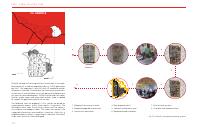
a participatory process within three months’ time-frame. The
UN-Habitat team maps the existing situation and the community validates and proposes ideas. The urban Lab rechecks the
suggested interventions and modifies if necessary. After that, a
neighbourhood assembly is organized to showcase the overall
vision and a land use is later developed.
112
A
15.
0
13.
8
7
LEGENDE/
LEGEND
A
M
S
Délimitation du quartier
Neighborhood boundary
Route nationale
National road
Artère
Arterial road 23m / 18m
15.
Rue principale
Main street 18m / 12m
Rue secondaire
Secondary street 12 / 9m
15.
ONA-VILLE AREA A /
PROPOSED INTERVENTIONS
REVIEWED BY THE COMMUNITY April 2016
(drone image July 2015)
15.
15.
9.
Zones résidentielles/ Moyenne densité
Residential areas / Medium density
10.
Zones résidentielles / Faible densité
Residential areas / Low density
12.
8.
Zones industrielles
Industrial areas
Zones spéciales
Special areas
DRAINAGE
11.
nouvelles routes prioritaires/ new priority routes
canaux primaires/ primary canals
canaux secondaires/ secondary canals
7.
SERVICES (source: open street map 22.01.2016)
Lieu de recueillement
Worship
Écoles et garderies
School / kindergarten
eau potable / drinking water
vente au détail / retail
sport / sport
écoles et garderies / school kindergarten
lieu de recueillement / worship
restaurant café / restaurant cafe
hôtel / hotels lodges
centre communautaire / community centre
hopital et clinique / hospital and clinic
établissement public/privé/ facility public/private
espace public réservé/ reserved public space
RUES / STREETS (source: open street map 22.02.2016)
national / national road
artère / arterial road
rue principale / main street
novelle rue principale / new main street
rue secondaire / secondary street
novelle rue secondaire / new secondary street
rue résidentielle / residential street
6.
5.
4.
Établissement public
(hôpital, administration, centre communautaire...)
Public facility
(hospital, administration, community center...)
Espace public (places publiques, marché, jardins...)
Public space (square, market, park...)
ZONES NON-AEDIFICANDI
(zones à risque: érosion, inondations, montagneuses...)
NON-AEDIFICANDI AREAS
(risk areas: erosion, flooding, mountainous terrain)
3.
Espace ouvert (zone tampon, corridor vert, réforestation, forêt...)
Open areas (buffer strip/green corridor, reforestation, forest...)
Zones de pâturage
Land for livestock grazing
2.
1.
500
ZONE A ONA-VILLE /
INTERVENTIONS PROPOSÉES
REVUES PAR LA COMMUNAUTE Avril 2016
(image drone Juillet 2015)
15.
Nouvelle rue
New street
Zones résidentielles / Haute densité
Residential areas / High density
Zones commerciales
Commercial areas
6
0
500
1000m
draft 14.09.2016
Ravines, rivières et ruisseaux
Ravines, rivers and streams
Onaville
land use plan / sketch / 14.09.2016
0
50
100
150
200
250
300 m
1. Mapping the existing situation
4. New proposals draft
7. Draft of land use plan
2. Mapping proposed interventions
5. Selected interventions map
8. Charrette and implementation
3. Community workshops
6. Neighbourhood assemblies
Fig.145: Onaville: participatory planning process
1000 m
1000 m
U r b a n D e v e l o p m e n t I n i t i a t i v e ( U r D I ) f o r C a n a a n a r e a o f Po r t - A u - P r i n c e
A. STREET NETWORK
The street network in Onaville needs to be improved in order to accommodate the vehicular flux
without leading to congestion. A need to preserve enough spaces for streets is important before
the area becomes urbanized. There is one arterial road that connects the national road to the upper
part and about ten main roads within the neighbourhood. Secondary streets are the most abundant types of roads in Onaville with an average of 6 metres’ wide. The current situation consist of
8% of space allocated to the streets while UN-Habitat recommends 30%.
The proposed street network does not only suggests new roads but also looks into improving the
current situation by widening the streets or paving them for example. Two options are offered,
with each, different widths are defined to the various types of roads. The UN-habitat recommendations on street space is achieved, forming 33% of the total neighbourhood area.
Existing situation
Proposed street network
Streets percentage
Streets percentage
UN-Habitat: 30%
33%
-Option A
24%
- Option B
Arterial road: 24m
Main roads: 18m
Secondary streets: 12m
8%
Arterial road: 18m
Main roads: 12m
Secondary streets: 9m
Streets km/sq.km
Streets km/sq.km
UN-Habitat: 18 km/sq.km
UN-Habitat: 18 km/sq.km
13.64 km/sq.km
20.1 km/sq.km
Fig.146: Onaville: existing street network
Fig.147: Onaville: Proposed street network
Layers of the proposed street network
National road
Arterial road
Main roads
Secondary streets
Fig.148: Onaville: Layers of the proposed street network
113
UrDI - Urban Structure Plan
B. PUBLIC SPACES
Existing Public Spaces
Proposed by UN-Habitat LAB
Proposed by the community
(incomplete)
(incomplete)
(incomplete)
(incomplete)
(incomplete)
(incomplete)
sting public spaces
Proposed public spaces by community
Proposed public spaces by LAB
500
1000m
0
3.11.2016
500
0
1000m
Fig.149: Onaville: Existing Public spaces
#
PUBLIC SPACES IN ONAVILLE
STATUS
NAME
Neighbourhood area
Fig.150: Onaville: Public spaces proposed by the community
m2
Ha
%
6,100,000
610
100%
1
Football field
Existing
3,600
0.36
2
Public space
Existing
1,300
0.13
3
Public space
Existing
3,500
0.35
4
Public space
Existing
6,500
0.65
14,900
1.49
6,000
0.6
43,200
4.32
Horeb? (park)
5
Public space
Proposed by the community
6
Sports centre
Proposed by the community
7
Market
Proposed by the community
33,600
3.36
8
Public space
Proposed by the community
20,000
2
9
Public space
Proposed by the community
4,900
0.49
10
Public space
Proposed by the community
14,600
1.46
11
Public space
Proposed by the community
Centre Sportif
Centre communautaire Onaville
Place Onaville
220
12
Public space
Proposed by the LAB
16,000
1.6
13
Public space
Proposed by the LAB
5,600
0.56
159020
0.24%
0.022
12.252
Total:
2.01%
2.16
0.35%
15.902
2.61%
Table 26. Onaville: Percentage of public spaces
114
500
1000m
produced 03.11.2016
produced 03.11.2016
Fig.151: Onaville: Public spaces proposed by UN-Habitat LAB
There are currently only a few existing public spaces within
Onaville. Four public spaces of which one is a football field, cover 0.24 per cent of the land mass. The UN-Habitat recommended
coverage of an area by public space is 15 per cent. This recommendation also implies that the public spaces are distributed equally among a neighbourhood, however the four public
spaces found in Onaville are situated only in the north-eastern
and central parts. In order to meet demand, build community
and enhance the urban life for the inhabitants, the presence of
public spaces is essential. Ideally they should be easily accessible
within a distance of no more than 400m in order to reduced
car dependency, facilitate availability and improve walkability.
These goals of the community were voiced strongly along with
improvement of the green space network during participatory
processes. The results have meant an increase of 2.0 per cent
of the land mass for public space in seven new areas. This also
includes a market as well as another sports centre.
U r b a n D e v e l o p m e n t I n i t i a t i v e ( U r D I ) f o r C a n a a n a r e a o f Po r t - A u - P r i n c e
Proposed public spaces with 400 metres buffer
Non-aedificandi areas also have the potential to become public
spaces. To further meet the UN-Habitat recommended land cover for public space, three public spaces are therefore proposed,
one of which is a buffer zone and two that are reforestation projects. These areas have been designed with the potential to become public spaces. If these suggestions are to be implemented,
designated public space in the neighbourhood of Onaville would
reach 11 per cent of the total land mass. Land for public space
should be encouraged to be developed in order to promote sustainable social dynamics within the new urban neighbourhood.
#
PUBLIC SPACE IN
ONAVILLE
STATUS
NAME
m2
Ha
%
Neighbourhood
area
6,100,000
610
100%
Public spaces
159020
15.902
2.61%
14
Reforestation
Proposed
by the LAB
200,000
20
15
Reforestation
Proposed
by the LAB
230,000
23
16
Buffer area next to
ravine
Proposed
by the LAB
93,000
9.3
523000
52.3
8.57%
682020
68.202
11.18%
Total:
Total open public spaces:
Existing public spaces
Proposed by the community
Proposed by UN-Habitat LAB
Table 27. Onaville: Total percentage of public spaces
The World Health Organization (WHO) recommends 9m2/inhabitant
Existing
Proposed
public space
Proposed
P.S + non-aedificandi
14,900 m2
159,000 m2
682,000 m2
22,700 inhabitants
49,000 inhabitants
49,000 inhabitants
0.65 m /inhabitant
3.2 m /inhabitant
13.9 m2/inhabitant
2
2
Table 28. Onaville: Public space area per inhabitant diagram
Fig.152: Onaville: Overall public spaces’ land use and buffer area (400m)
115
UrDI - Urban Structure Plan
C. RESIDENTIAL AREAS
6.43 km2
Proposed densities
Neighbourhood area
Low density
Low density housing are suggested where topography is too
challenging to be built or where flooding is likely to occur proving challenging for sustainable construction. As seen on the
above plan, most of the northern part of Onaville have been
designated as such. For low-density settlements, it is proposed
that the density be 8 000 people per square kilometre, mainly in
the northern area. The existing dwellings may remain although
it is recommended that the site not be built further resulting in a
low density portion of the neighborhood. In the future, as technology availability and improves and emerges, these areas have
the potential to become higher density.
22,663
Inhabitants
(source ARC household survey 2016)
3,524
people/km2
Existing residential areas
Fig.154: Onaville: Projected population increase
Medium density
The topography, where medium density housing is proposed, is
fairly steep but still considered suitable for settlements. The level
of densification also depends on proximity to arterial roads and
main streets as well as commercial and service-oriented areas.
The areas in between these important connections and the more
urbanized areas is therefore suggested as medium density housing. A density of 12 000 people per square kilometre is suggested in these areas to encourage social mixing and better opportunities for interaction of more vulnerable populations.
Fig.153: Onaville: Existing settlements
Onaville is a neighborhood with medium density. This is due to
it being situated far from the more urbanized areas of Port-auPrince as well as factors of a very challenging terrain.
116
Fig.155: Onaville: Contours
The expected growth of Onaville is 4 per cent annually.
High density
For high density areas, a density of 15 000 people per square
kilometre is suggested. This type of neighborhood profile is suggested mostly along arterial roads, main streets and at junctions.
High density areas are preferably combined with commercial and
service facilities in order to promote a mixed used. In Onaville
this has been proposed in the southern and central parts of the
neighborhood. Encouraging a compact urban form aims to increase the built area and residential population densities. It also
has the goal of intensifying urban economic, social and cultural
activities while manipulating urban size, form and structure with
larger goals of improving environmental, social and global sustainability benefits.
U r b a n D e v e l o p m e n t I n i t i a t i v e ( U r D I ) f o r C a n a a n a r e a o f Po r t - A u - P r i n c e
Fig.156: Onaville: Diagram of population in the new proposed
residential areas.
Throughout Onaville, not all areas for residential land-use are to
be purely monofunctional; integration of mixed-use land types
into the residential urban fabric is key to encouraging walkability,
promoting inclusion of vulnerable populations and maintaining
social cohesion. These areas are distributed equally throughout
the neighborhood with the goal of incubating small local businesses, artisan workspaces, eateries and government service
centres. Mixed-use nodes in the neighborhood are designed to
augment the existing commercial areas providing ease of access
and possibilities for new urban form.
The expected annual growth of Onaville is 4 per cent. This means
that the current population of 22,663 will grow to approximately
49,657 people within 20 years. The densification of Onaville, as
proposed in numbers seen above, will be able to accommodate
41,646 people.
Low density
Medium density
High density
Fig.157: Onaville: Residential areas and proposed densities
117
UrDI - Urban Structure Plan
D. COMMERCIAL AREAS
Existing commercial
Proposed commercial areas (mixed-use)
285
Existing
commercial
points
7%
(of the total
neighbourhood area)
(source OSM)
Fig.158: Onaville: Existing commercial points (Source: OSM)
Fig.159: Onaville: Proposed commercial areas
According to OpenStreetmap, there are 285 retail points in Onaville. There is no concentration of commercial activities, the retail shops are dispersed within the neighbourhood and
mainly found in the northern area. These shops are a combination of different uses like vegetable shop, merchandise, hairdressers and so on. In order to keep pace with the 4% urban
growth, more commercial facilities are needed. With the provision of more centralised commerce facilities and the planning of an adequate street network, Onaville will also induce job
opportunities for its residents.
Following the workshop with the communities, different commercial streets where identified.
The location of the new commercial shops will be highly concentrated on the arterial roads,
as well as on the main roads. This will enable the residents to access those facilities easily. The
centres of activities are a booster of employment opportunities and therefore a catalyst for
local economy.
118
It is important to note that the commercial centres are not mono-functional and are not limited to retail activities. These areas are encouraged to be mixed-use where different functions
can exist at once. Usually, they have commercial and public facilities on the street level and
high residential on the upper level.
U r b a n D e v e l o p m e n t I n i t i a t i v e ( U r D I ) f o r C a n a a n a r e a o f Po r t - A u - P r i n c e
E. PUBLIC FACILITIES
There are 25 existing schools within the Onaville area, including kindergartens. These schools are well distributed throughout
the neighborhood and are on track to support the growth in
population. Therefore no new schools are suggested, however
improvement to facilities and quality of education programs are
recommended in the SDF.
RELIGIOUS - EXISTING
EDUCATION - EXISTING
HEALTH - EXISTING
OTHER PUBLIC FACILITIES - EXISTING
There are 30 places dedicated for worship in the neighborhood
of Onaville. The frequency of worship centres currently follows
closely with the density of the population. Where the density is
high, more or perhaps larger religious centres can be provided
and vice versa in areas considered as low density.
Fig.160: Onaville: Existing public facilities and
a 500m buffer catchment area.
11%
Less than 10 years
4%
Illiterate
29%
Primary school (not finished)
11%
Primary school (finished)
29%
Secondary school (not finished)
8%
Secondary school (finished)
2%
Professional school
5%
University
Table 29. Onaville: Participation level (Croix Rouge Americaine, Juillet
2016)
There are no information available about health services, community centres, security stations and others. For planning purposes, and in order to have a long-term sustainable city, it is
essential to consider the services mentioned in the new design
of the neighbourhood. Generally, these services require good accessibility and therefore their location must be well studied. Normally, it is recommended to locate them within 500 metres from
the settlements so that they are easily accessible.
Fig.161: Onaville: Existing public facilities
119
UrDI - Urban Structure Plan
F. NATURAL RESOURCES AND ENVIRONMENT
Eight percent of the Onaville region is suggested to be non-aedificandi areas. These zones are for the purposes of environmental protection and public engagement in environmental issues,
and must be coupled with educational programs to encourage
civic and environmental responsibility among civil society. Buffer
zones are suggested along rivers that run in the north-eastern
part of Onaville. These green corridors are preserved in order to
mitigate flood risk and to protect the natural environment. A
width of 30 metres on either side is recommended as a minimum
width for the buffer zone although the topography of a certain
areas may not always allow that recommendation to be enacted.
Currently the river passes through several settlements targeted
for low density housing, so these areas are not recommended
for further expansion.
The north-eastern parts of Onaville are preserved for reforestation projects. Further south, an area is suggested either for reforestation, agricultural or livestock grazing zones. These areas
are to be developed according to the Tree Planting Strategy. The
Strategy implores the use of certain native species of trees in
certain areas. For example, trees and plants that have a large
amount of water uptake are recommended for floodplains. This
includes fruits, vegetables and grains that can be grown in these
contexts for the purposes of agriculture.
#
No-built areas
m2
Ha
%
Neighbourhood area
6,100,000
610
100%
14
Reforestation
200,000
20
15
Reforestation
230,000
23
16
Buffer areas next to
ravine
93,000
9.3
523000
52.3
Total:
8.13%
Table 30. Onaville: Total percentage of no-built areas
Legend
Proposed buffer zone along the rivers and ravines
Proposed area for livestock grazing
Proposed area for reforestation
High environmental risk areas
Existing rivers and ravines
Quarries
120
Fig.162: Onaville: No-built areas
U r b a n D e v e l o p m e n t I n i t i a t i v e ( U r D I ) f o r C a n a a n a r e a o f Po r t - A u - P r i n c e
G. ONAVILLE LAND USE
(incomplete)
(incomplete)
The overall land use of Onaville is a result of ongoing engagement with the community. The plans reviewed by the residents
and the neighbourhood leaders were the basis of UN-Habitat’s
land use proposal. Streets forms 27.6% of the total land in the
new proposal, whereas public space and non-aedificandi areas
takes 10.6% of Onaville.
Onaville’s land use was also reviewed in its wider area, taking
into consideration the neighbourhoods nearby and how they interlink. It is mandatory to situate the individual neighbourhood
plans within the overall Canaan area in means to reach a consistent and rich structure.
0
500
1000m
produced 03.11.2016
Fig.163: Onaville: Proposed land use plan
121
Comment citer
UN-Habitat; UCLBP, 2016, UrDI zone de Canaan : plan de quartier pour Onaville, https://unhabitat.org/sites/default/files/2020/09/89._neighborhood_plans_en_onaville.pdf