Description Complète
Moniteur saisonnier de FEWS NET pour Haïti, novembre 2025, daté du December 2, 2025. Les pluies sur Haïti ont été inférieures à la moyenne en novembre, après que l'ouragan Melissa a causé des impacts catastrophiques fin octobre, avec des décès et des dégâts importants aux infrastructures et aux terres cultivées. Les cumuls les plus élevés pendant Melissa, supérieurs à 300 pour cent de la moyenne historique, ont été signalés dans la Grand'Anse, le Sud, les Nippes, le Sud-Est, l'Ouest et l'Artibonite. Des pluies moyennes étaient prévues pour les sept jours suivants. Le moniteur suit la saison en cours : cumuls pluviométriques rapportés à la moyenne de long terme, état de la végétation à partir du NDVI satellitaire, et ce que les deux impliquent pour les semis, le développement des cultures et la récolte. La date de couverture clôt la fenêtre de 30 jours couverte.
Texte Intégral du Document
Texte extrait du document original pour l'indexation.
Haiti - Seasonal Monitor
December 2, 2025
Below-average rainfall in November over Haiti
Key Messages
Below-average rainfall over Haiti during November 2025.
Average rainfall forecast for next seven days suggest average conditions.
Below-average rainfall after hurricane Melissa over Haiti
Hurricane Melissa brought catastrophic impacts to Haiti in late October, resulting in fatalities and significant damage
to infrastructure and cropland. The highest rainfall totals—exceeding 300 percent of the historical average—were
reported in Grand'Anse, Sud, Nippes, Sud-Est, Ouest, and L'Artibonite. Over a five-day period, rainfall surpassed
400 mm. The accompanying gusty winds, flooding, and landslides damaged irrigation systems, which could pose a
challenge for farmers in the upcoming planting seasons.
Since the beginning of November, rainfall has been sporadic and light. This has aided the drainage of flooded areas,
replenished water storage in reservoirs, and facilitated crop activity in areas where irrigation systems were not
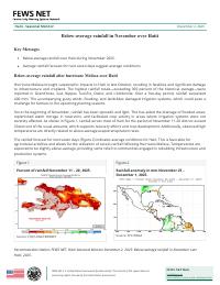
severely affected. As shown in Figure 1, rainfall across most of Haiti for the period of November 11-20 did not exceed
30 percent of the usual amounts, which supports recovery efforts and crop development. Additionally, observed high
temperatures are directly related to above-average evapotranspiration rates.
The rainfall forecast for next seven days (Figure 2) indicates average conditions for Haiti. This is favorable for
agricultural activities and allows for the utilization of excess rainfall following Hurricane Melissa. Temperatures are
expected to be slightly above-average, providing some relief to communities engaged in rebuilding infrastructure and
production systems.
Figure 1
Figure 2
Percent of rainfall November 11 – 20, 2025.
Rainfall anomaly in mm November 25 –
December 1, 2025.
Source: CHC/USGS/FEWSNET
Source: CPC/NOAA
Recommended citation: FEWS NET. Haiti Seasonal Monitor December 2, 2025: Below-average rainfall in November over
Haiti, 2025.
FEWS NET is a United States Government-funded activity. The content of this report does not
necessarily reflect the view of the United States Government.
FEWS NET Haiti
haiti@fews.net
fews.net/latin-america-and-caribbean/haiti
Seasonal Monitor
December 2, 2025
Seasonal Monitor
FEWS NET’s Seasonal Monitor reports are produced for Central America and the Caribbean, West Africa, East Africa, Central Asia, and Somalia every 10-to-30 days during the region’s
respective rainy season(s). Seasonal Monitors report updates on weather events (e.g., rainfall patterns) and associated impacts on ground conditions (e.g., cropping conditions,
pasture and water availability), as well as the short-term rainfall forecast. Find more remote sensing information here.
Famine Early Warning Systems Network
2