Description Complète
Moniteur saisonnier de FEWS NET pour Haïti, août 2024, daté du August 31, 2024. La sécheresse et des températures supérieures à la moyenne sont revenues dans l'est d'Haïti sur les quinze derniers jours, les pluies de l'est se situant entre 75 et 90 pour cent de la normale. Anse-Rouge et Gonaïves montraient des signes de mauvaise santé de la végétation, et une zone d'averses désorganisées sur l'Atlantique tropical central était associée à une onde tropicale. Le moniteur suit la saison en cours : cumuls pluviométriques rapportés à la moyenne de long terme, état de la végétation à partir du NDVI satellitaire, et ce que les deux impliquent pour les semis, le développement des cultures et la récolte. La date de couverture clôt la fenêtre de 30 jours couverte.
Texte Intégral du Document
Texte extrait du document original pour l'indexation.
Haiti - Seasonal Monitor
August 31, 2024
Below average rainfall in eastern Haiti
Key Messages
Dry conditions and above average temperatures returned to the eastern area of Haiti in the last 15 days.
An area of disorganized showers over the central Tropical Atlantic is associated with a tropical wave.
Areas in Anse-Rouge and Gonaives show signs of negative vegetation health.
Update on Seasonal Progress
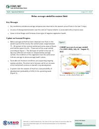
Below-average rainfall has been observed over Haiti. In the
eastern parts of the county the rainfall values range between
75 – 90 percent of the normal rainfall and some areas of Ouest
and Sud-Est report the 60 – 75 percent of the usual rainfall
according to Figure 1. The decrease of rainfall in the last 15
days has affected soil moisture. Despite below-average
rainfall, the conditions of the vegetation over the same areas
indicate average to above average health values.
Figure 1
CHIRPS percent of average rainfall
(%) (1981–2010), July 26 – August 25,
2024
Favorable soil moisture conditions are supporting ongoing
sowing activities. The short-term forecast call for an increase
of the rainfall will continue to benefit crop development.
A system over the eastern of Haiti has a low possibility of
development (probability of 20%) in the upcoming week
(Figure 2).
Source: UCSB-USGS/FEWS NET
FEWS NET is a USAID-funded activity. The content of this report does not necessarily reflect the
view of the United States Agency for International Development or the United States
Government.
FEWS NET Haiti
haiti@fews.net
fews.net/latin-america-and-caribbean/haiti
Seasonal Monitor
August 31, 2024
Forecasts
Figure 2
According to the climatology, September is the peak of
hurricane activity over the Caribbean basin. Any disturbance
system has the potential to change the short and mid-term
rainfall forecast and could increase the risk of floods and
landslides.
Atlantic 7-Day Graphical Tropical
Weather Outlook
The most-recent forecast from the University of Colorado for
this year’s hurricane season indicates an above-average
season.
Based on mesoscale models, above-average rainfall is
expected for the remaining first half of the second rainfall
season. However, the erratic distribution of rainfall, in time
and space, will persist.
Above-average temperature will favor conditions for pest and
diseases.
Source: NHC/NOAA
Recommended citation: FEWS NET. Haiti Seasonal Monitor August 31, 2024: Below average rainfall in eastern Haiti,
2024.
About Seasonal Monitor
FEWS NET’s Seasonal Monitor reports are produced for Central America and the Caribbean, West Africa, East Africa, Central Asia, and Somalia every 10-to-30 days during the region’s
respective rainy season(s). Seasonal Monitors report updates on weather events (e.g., rainfall patterns) and associated impacts on ground conditions (e.g., cropping conditions,
pasture and water availability), as well as the short-term rainfall forecast. Find more remote sensing information here.
Famine Early Warning Systems Network
2